
My plan this year was to do three trips this year in areas where I had never backpacked before. The first was out of the Sierra altogether, in the Trinity Alps (in the northwest quadrant of the state). It's an area I've been thinking about for years: it's a big wilderness (500,000+ acres); it has some of the very few truly alpine areas in California outside the Sierra; and it was reportedly great wildflower country. With a lot of help from Messrs. Linkhart and White, I put together a planned loop with several lakes, some interesting cross-country, and a whole lot of wildflower potential: from Long Canyon Trailhead to Anna Lake, Diamond Lake, Deer Lake, and then out. The downside: a 3,700' gain the first day, with the toughest (off-trail) part coming at the end of the hike.
At some point I managed to get my buddy Lou interested enough to come along...despite his misgivings about the first day's climb. We met at his place the morning before, and drove up together--with stops in Redding (for the Sundial Bridge) and Weaverville (for lunch and a tour of the Joss House). We crashed out at the trailhead so we would get the most time at the highest possible elevation and the earliest possible start.
Good thing, because when we hit the trail at 6:00 am we could tell it was going to get good and warm.
More...
The Long Canyon trail starts out steep and just keeps climbing. The good news was that it was all shaded in the early stretch, which kept it cool; the bad news was that it was also pretty boring. We chugged along in low gear, steady and slow. At about two miles we got to the Bowerman Meadows trail, dropped down to cross Long Creek, and started climbing again on the other side. 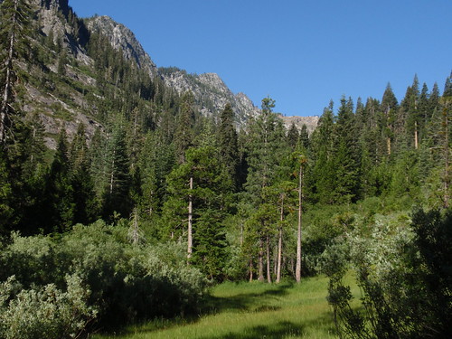
After a short climb we got to the first small meadow, the first good views of the cliffs above, and the first of the Naked Mariposa Lilies that were so spectacular in the upper meadows. Then another longer climb away from the stream, and a traverse through a boggy section chock full of wildflowers: Leopard Lilies, Bog Orchids, Crimson Columbine, etc.
Three words about the wildflowers in this section (from this point to the valley headwall): Anne. Croy. Obbler. Whole fields of Mariposa Lilies, Cinquefoil, Yarrow, and Scarlet Gilia and Larkspur for highlights; underfoot, easy to miss, lots of tiny Monkey Flowers.
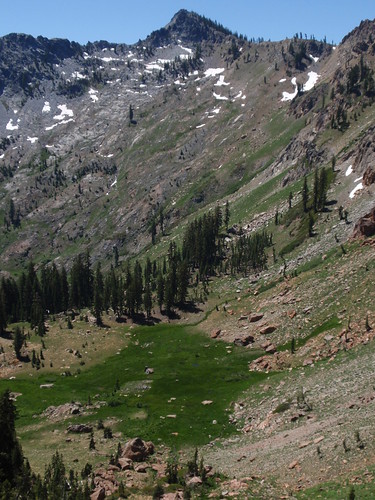
After another short climb we came out into a large open area, the main body of Bowerman Meadows. This is where I think we went wrong. We followed the obvious trail to where it sort of petered out at the edge of the forest. We picked up something that looked like a trail that led toward the stream, and then died a horrible death in a willow thicket. Huh.
So we backtracked a bit and then headed straight up the open slopes, figuring we might get the views needed to better orient ourselves, and at any rate the going would likely be easier higher up. A couple hundred feet up we got to a sort of bench, where we found...trail. Apparently when we got to the main meadow, we should have looked for a faint trail heading upslope instead of following the beaten path on the level. (Linkhart and White actually describe this, by the way.)
From here it was straightforward on-trail hiking, traversing the slope with a gentle climb up to the flat below the headwall. It's an idyllic spot--lush meadow, mountain stream, dramatic cliffs, and the cascading stream out of Lake Anna--so we took a break here and planned out the off-trail portion of the day's hike. 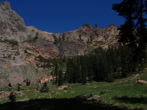
Moving again, we started the climb. Following Linkhart & White's directions, we followed the Lake Anna outlet stream for a ways, until the grade got steeper, then turned and angled right (northish) up the ridge. It's a steep climb with some loose stuff (not too bad, but watch your footing) and large patches of brush to find your way through or around. The best bet is to stay left of the large outcrop (described as a 'boulder' in the book) and just keep climbing; when you get to what looks like the ridgetop the grade eases up and you have a short further climb to a saddle on the true ridgetop.
We were tired, but feeling okay--believing, naively, that the hard part was over.
Following the book, we turned left here and headed up a short steep gully. At the top...ugh: snow choked the gully down the other side, which would have been the natural route. At first it looked like we needed to traverse across the large snowfield to a gap high on the left--not an encouraging prospect.
Then I remembered what it said in the book: "make a short descent into this basin, traverse around the base of the cliffs, and head up to a minor ridge on the opposite side." There was a clear notch on the opposite ridge, so we figured that was our route. We clambered cautiously down the rocks to the less-precipitous slopes below, and angled up to the notch on the other side.
And once again: cliffs and snow. This is the point at which I really started feeling exhausted. The troublesome thing here was not just the steep-angled snowfield itself, but also the gap one had to cross to get on it in the first place. Again, we eased our way down the rocks to where the snowfield was a little more level. Here, Lou got onto the snow with a tricky move off a narrow foothold; not trusting my rubbery legs, I followed the snow gap (just wide enough to walk through) to the lower edge of the snowfield.
Now we were in the gully north of Lake Anna, and it was pretty easy from here...or would have been, if I weren't so wiped. (I did, however, have enough energy to stop and shoot the Glacier Lilies I spotted along the way.) The gully seemed endless, and there was at least one false crest along the way. 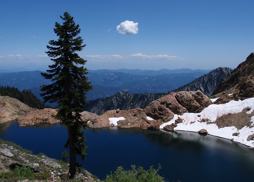
At the top of the ridge, with the lake finally in view, I was ready to drop at the closest campsite. (All of the feasible campsites at Lake Anna are well above the lake, on a high bench.) Lou was not; he wanted the best campsite. "Didn't anyone ever tell you that adequate is good enough?" I asked him, rhetorically. In fairness to Lou, he did find us a pretty swell site that wasn't too much further: great view, level sleeping sites, and water (the inlet stream) was just a short level jog to the south (rather than a steep descent to the lake and climb back up).
We settled into camp around 1 pm, a good 7 hours after setting out that morning. Reading, napping, a little whiskey--an afternoon spent recovering from the day's hike.
Later, early evening, Lou and I wandered over to chat with Don and Griff, two guys from Portland camped on the saddle north of Lake Anna. (Also a swell view: while we could see east as far as Mt. Lassen, they looked out at Mt. Shasta.) Very nice guys, generous with the hooch and knowledgeable about the area--and after talking with them we wound up altering our trip plans (wisely) on the basis of their information.
Then back to camp, dinner, and bed.
Part 2
Thursday, July 16, 2009
Trinity Alps Trip Report: Part 1
Subscribe to:
Comment Feed (RSS)
|