
Up and moving by 6:45 on day 3. I was expecting this to be my most difficult day: something like 6 miles of off-trail hiking, according to the Topo! route. Back when I first planned this trip, I thought I'd camp near Rock Island Lake; on closer inspection, I decided the camping didn't look great there (too exposed, no shade) and it made for a long hike out, so I'd be better off pressing on to Snow Lake. So I had what looked like a long day ahead of me.
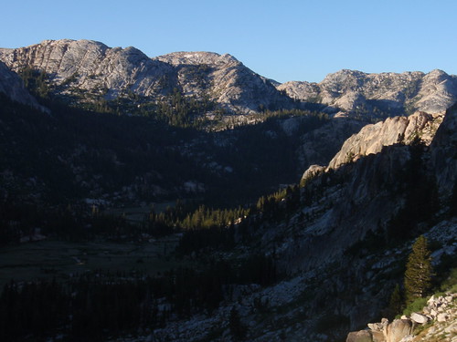
The ramp out of Slide Canyon (visible on the topo as a diagonal notch running roughly north) is choked with talus and willow in the lower reaches; fortunately, there are low-angle slabs to the east of it so you can bypass that section. Aim for a prominent rust-stained cliff, which happens to be the exact point where the talus and willow end. Once you're on the (surprisingly broad) ramp, it's easy going: just follow it up.
More...
The stream shown on the map actually drops into the canyon sooner than the map shows; you'll start hearing it when you're halfway up or more. When the terrain started to open out, I bore left, skirting the southern edge of the big meadow at the top. This area is just magical: wide-open alpine meadowlands surrounded by classic Yosemite outcrops, and (once you're on the broad saddle) great views down Crazy Mule Gulch. 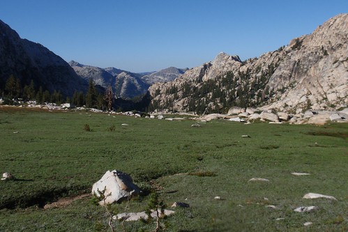
You make your way through this beautiful and easy terrain toward the obvious knob to your west. Easy slopes lead up to the best crossing of this ridgelet, at a forested notch immediately north of the knob. From here you descend a short ramp and then a short sandy slope into the gully to the west. Follow up the gully a little ways, then zigzag west to the top of Suicide Ridge, following the plethora of low-angle ramps that lead you up and west. At a broad flat atop the ridge, I angled northish through a nice granite alley and emerged to my first view of Rock Island Lake. 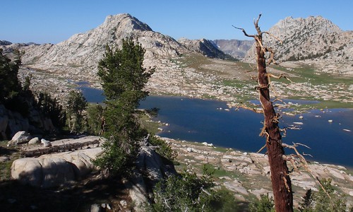
Which is really an extraordinary lake: a mile or so long, nestled in a vast meadowy valley, a landscape so open and inviting you can almost picture living there.
Zigzag ramps lead quickly down to the gentle slopes nearest the lake. I followed the lakeshore north and crossed the inlet stream just a little ways past the north end, with the aim of cutting directly west to the western slopes of the valley and the most direct shot up to the next pass. This was not a bad plan, but the turf is pretty hummocky in places; it might have been slightly easier crossing the valley a upstream a ways. Once across, though, it's an easy, gentle angle right up to the pass.
From the pass, my goal was to traverse over to Rock Island Pass while losing as little elevation as necessary to avoid the most difficult terrain. A series of benches lead inexorably lower, but as long as you keep heading northish as you drop you should be fine. The slopes gentle out some after a while, and at this point you want to stay level or gain elevation. I came out right in the big meadow, and hooked up with the trail about 100 yards before the pass.
Just a short hop down the trail and I was at Snow Lake. Which I reached at...a few minutes after 11 am. The whole route went so smoothly that it wound up seeming like the easiest day rather than the hardest. 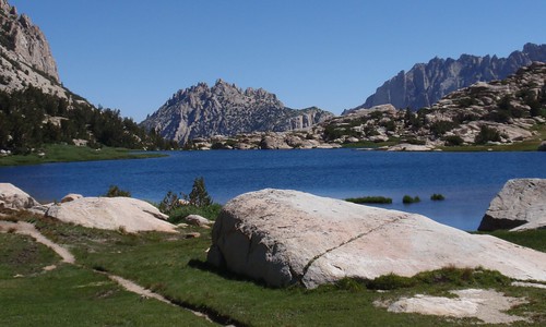
I took a cursory look around for campsites here. Not finding much, and being less than thrilled by the stiff wind blowing steadily through Rock Island Pass, and in light of how early it still was, I decided to continue on to Crown Lake. 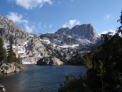
Where I found a secluded campsite well away from the group of eight who were my nearest neighbors.
That night the wind never stopped. There's white noise, and then there's white noise: the sound of a nearby stream can be wonderfully relaxing, but the sound of the wind unsettles me and puts me on edge. It was not a restful night.
Nevertheless, I was up and on the trail by 6:36 am. Not much worth telling about the rest of the trip, beyond my supreme annoyance at the trail builders. Three crossings of Robinson Creek in a quarter mile? Those ridiculous switchbacks up and then down before Barney Lake? What on earth were they thinking?
Oh, and one more thing. In the last flat tedious section of trail, approaching the campground, as I was wanting nothing so much as to be at my car already, I stopped to talk with a couple who were hiking in. I asked where they were going, and the man said Rock Island Lake. So I described my route, and it turned out that they were thinking about doing that same stretch between the lake and Slide Canyon (except possibly in reverse). They were iffy, because they weren't sure about the ramp up from the canyon. I described in detail what I had done and what landmarks to look for, and told them what a sweet route that ramp really is, and enthused over Rock Island Lake and environs. And when we parted I felt a whole lot better: here, in the most tedious part of the whole journey, they had given me the opportunity to relive the most enjoyable part of it all.
Part 1
Part 2
Tuesday, August 31, 2010
Yosemite/Hoover Wilderness Trip Report: Part 3
Subscribe to:
Comment Feed (RSS)
|