
This was a loop from Cherry Creek up Kibbie Ridge and off-trail to the lakes east of there. Part of the idea behind it was the possibility of climbing Nance Peak, which had loomed above us on our Kendrick Canyon trip; also, pretty lakes and lots of exposed granite. My longtime hiking buddy Lou was originally planning to go with me, but as the spring wore on his back problems made it iffy; in the end, he decided to start out with me and see how it went.
When we got to the Kibbie Ridge trailhead, I had a bit of a shock: the area had burned over, 3 or 4 years before (since my last time here, a Cherry Lake trip Lou and I had done out of this trailhead). Instead of forest on the downhill side, there were now open views across the snags down to Cherry Lake. 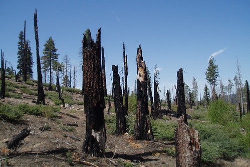
This made the first few miles of trail mostly shadeless and kind of ugly. It was never the most exciting stretch of trail, but now it was even less appealing.
Lou's back started bothering him early on, and not long after the Kibbie Lake turnoff he decided to cut his trip short. We parted just past the stream that forms the Emigrant Wilderness border, and he headed left to camp in the open slabs overlooking Cherry Creek Canyon. I continued up Kibbie Ridge alone, sorry to lose a good hiking companion but still glad to be out in the backcountry.
I was out of the burn area shortly after that, hiking through forest with occasional swampy meadows. I took a short break at Lookout Point for the view, but the sky was full of hazy high clouds that just weren't very photogenic. A mile or so after that, a couple of faster hikers passed me--the last people I saw on the trip.
After some more relatively level meandering, the trail started climbing steeply up the ridge. At a broad sandy saddle right on the Yosemite border, I finally got some views east and south toward the higher peaks. Still too hazy for decent pictures, though.
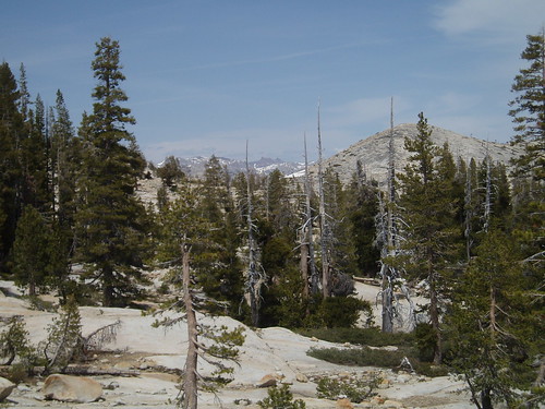
Sachse Spring was pretty much one big swamp, and I stopped there just long enough to get water. I veered away from the trail here, to avoid the swampiest part of the little valley, then rejoined it up the hill a ways. I crossed a low rise and, some 7 miles in, finally got into the open granitic country I had come here for (see the first photo, above). I was getting pretty tired, but I was damn glad to see all the granite.
At this point, the trail was sort of intermittent, but it didn't really matter; the direction was pretty obvious. I meandered on and off it until the tarn west of Styx Pass, where I cut south over a series of low granite ribs to the friction slabs leading down to Many Island Lake. 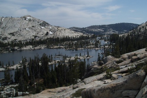
I picked my way down the steepish slabs to the forested west side of the lake, reaching the bottom around 4 pm. I circled around to the north and found a campsite well away from the shore at the base of a huge expanse of low-angle granite slabs. The downside of this site was that I couldn't actually see the lake at all...but at least the mosquitoes weren't too bad. 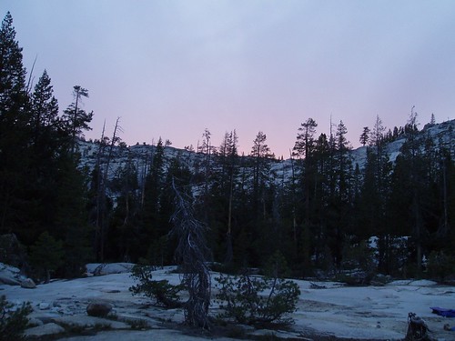
Meanwhile, the skies I had been watching dubiously all day didn't get any better; by early evening, the clouds had coalesced into a high hazy overcast layer--the sort of thing that often presages a front moving in. Just what I needed. Your basic afternoon thunderstorms are no big deal, but you get the sort of storm where it rains all day and you might as well just pack it in. I was paranoid enough about the weather to set up my tent, just in case it started raining in the middle of the night (if you've ever set up a tent in the rain, you'll understand). I went to bed exhausted and thoroughly demoralized, resigned to the likelihood of having to pack up and hike out in the rain the next day.
The cloud layer lasted well after midnight, then cleared up...and that was the end of the weather scare.
Part 2
Part 3
Part 4
Saturday, June 02, 2007
Northwest Yosemite Trip Report: Part 1
Subscribe to:
Comment Feed (RSS)
|