
Part 1
Part 2
I had a lazy Sunday morning, sleeping in until 5:30 am and not getting out of camp until almost 7:00. After Saturday's brushapalooza, I had some trepidation about today's route...but I figured the best approach was not to be in any kind of hurry, and try to look at any extended detours as the scenic route. Which, of course, is arguably how one should always look at it when backpacking...but when you do have a destination, it's easy to fall into a mindset in which the point is getting there rather than enjoying the journey.
I found a way back over the ridge to Bartlett Creek that I'm pretty sure wasn't exactly the way I had come (that reverse-route Alzheimer's again), but was pretty easy anyway. From the saddle west of Spotted Fawn, I angled southwest to the south shore of the lake on Bartlett Creek. It was easy walking along the lakeshore; even when a granite rib looked like it might make me detour, it turned out there was a nice way over it.
I continued down through the next valley--lots of slabs, occasional low brush but nothing too bad--to the dropoff, the point about which I had been most concerned. On the map, it looked like the best route might be contouring south away from the creek and dropping into the next big lake basin. 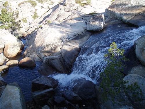
And yes, it was steep at the rim--with a mini-waterfall to prove it--but again, once over a low rise immediately south of the falls (and I could actually have skirted this rise closer to the creek), nice low-angle slabs led down into the next valley.
At this point, I started to wonder about the origins of the route I was following. At key decision points along the way, I kept running across helpful bits of--not quite 'trail' exactly, but clear signs that others had traveled this way. At several of these points, there were helpful little mini-stairways of stacked rock--the sort of thing that occurs naturally, of course, but also the sort of thing that would have to be constructed if you wanted to bring horses over this route. And I recalled that Flora Lake had been considered for a base of operations when the Army was patrolling the park, back before the Park Service was created. And from Flora, of course, a route up Bartlett Creek would have been logical and necessary. And so I wondered if maybe what I was following was traces of a trail the Army had used a hundred years ago.
Pure speculation--but not unlikely, I think.
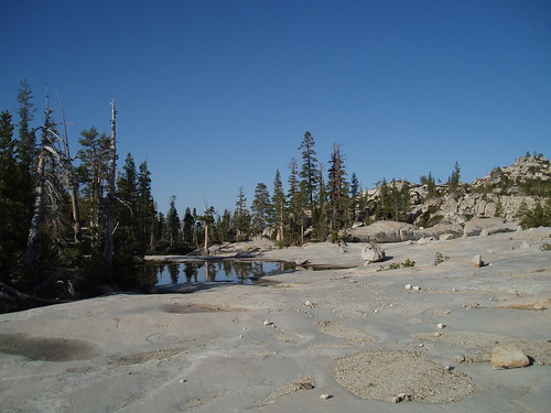
Anyway, I continued fairly close to the creek, then veered away at the largest lake. As I approached the next lower (Y-shaped) lake, the way got rougher and brushier, with some down trees and some granite ribs to climb over, but still nothing too daunting. I had to backtrack a couple of times, but it was still early in the day, and I didn't let it bother me. At some point in here I stumbled into a mini-valley that had been recently burned (I think it was the Bart fire, in July 2006, listed here); it was kind of spooky, with burned trees all around and ash underfoot. Then over a rib and on to the next valley.
The terrain gets fairly complex between the Y-shaped lake and the lowest of the Bartlett Creek lakes, and the 'trail' is pretty much gone. (It might well have crossed the creek above the lowest lake; my way did entail a wide detour around the east side of the lowest lake.) 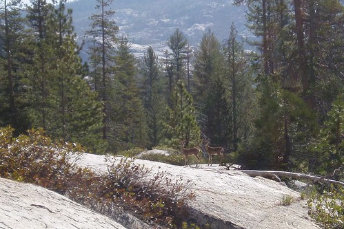
Keeping the lake in sight, I steered my way toward Bartlett Creek, which I crossed on big rocks in a gully just below the outlet. More brush, by the way.
Once out of the gully, though, it was nice slabby walking southwest toward Flora. I avoided some brush by staying high on the slabs, above the forest fringe around the lakelet below Flora. Flora itself appeared before I expected it. I circled south of the lake, mostly on slabs with a couple of brushy gullies to cross, to a vast expanse of granite slab on the southwest side. I set up camp about a hundred yards from the lake, where a couple of trees growing out of the slab gave me some shade. It was a little after 10:00 am; the whole trip had taken just three hours.
Spotted Fawn Lake was pretty, but sort of a cul de sac. Flora is much more open, with good views of the Bartlett Creek canyon complex. Also, great slabs. 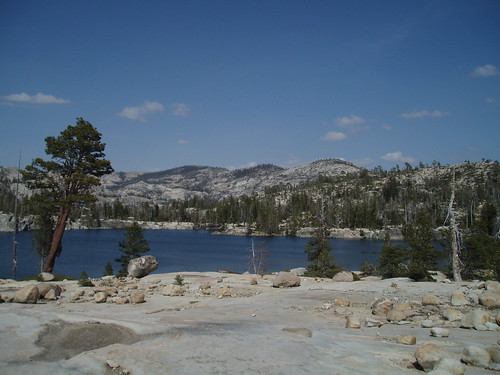
That afternoon, I went scouting around for the U-shaped lake southwest of Flora, which Schifrin says is key to finding the best route between Flora Lake and the trail. I missed the lake at first, shooting a little too far north and getting too high, then backtracked south and found it--which made me glad I was making this mistake on a dayhike rather than the next morning with a full pack. While walking beside the lake, I happened to look up at the rocks above and saw a smallish bear loping along the slabs.
Back to camp, reading, happy hour, dinner, yadda yadda yadda. Again I picked out a slab with a view to bed down on, and again the frogs serenaded me to sleep. This was the best day of the trip--good, challenging cross-country travel, but not too much of it, and lots of time to sit around camp reading.
Part 4
Tuesday, June 05, 2007
Northwest Yosemite Trip Report: Part 3
Subscribe to:
Comment Feed (RSS)
|