
It wasn't the trip I planned, but it was a great trip nonetheless.
I had an extremely ambitious plan to get into the lakes on the east side of the LeConte Divide, north of Hell-for-Sure Pass. My route was pretty strenuous and entirely speculative--I wasn't sure if some of the passes I planned were even doable--but if it did work, it would get me into some remote and spectacular country that nobody else I knew had ever seen.
That was the plan.
A week or two before the trip, my friend Lou (who had been forced to bail on our last trip) e-mailed me to tell me his back was better, his plans had fallen through, and could he come along. I said sure; we both understood we would have to play it by ear, and he might end up having to bail, but it was worth a try.
Lou and I met up Friday night at an unofficial campsite off the Kaiser Pass Road. Next morning we left promptly at 6:30 and drove the ~17 miles to Florence Lake to catch the ferry over to where our trail began.
We got to the landing before 8, and already there was a flurry of activity there--related, we learned, to a monster wedding the next day. A few miles up the trail from Lake Florence there's a private inholding called Muir Trail Ranch, where people with the means can do the wilderness in style--beds, horses, gourmet food, that kind of thing. (They also provide helpful services to JMT/PCT through-hikers.) The bride was from the Muir Trail Ranch family, and they were going to have 350 overnight guests at the ranch. Every guest was given a yellow bandanna with a line-drawing map of Luke & Hillary's wedding site; you had to have a yellow bandanna to ride on the wedding boat, which was the regular Florence Lake ferry only festooned with tulle (and that's a phrase you don't often read in backpacking trip reports). Getting everyone there was clearly an enormous logistical undertaking. They even had helicopters for a few of the oldest guests, who would have been unable to hike the couple of miles in.
Anyway, we wished them all luck and rode in the other boat across the lake. Unfortunately, the water was too low for a drop-off on the south arm of the lake, so we got off at the main landing and had an extra mile to hiking. This is an extremely annoying mile, because after climbing a few hundred feet and then dropping it you end up a) at exactly the same elevation you started at, and b) where you wanted to start hiking in the first place. By the time we got to the bridge over the South Fork, it was nearly 10 am and getting warm. 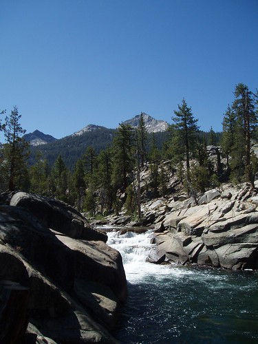
I had a pretty strenuous day planned: head up to Mt. Shinn Lake, over Mt. Shinn Pass, east along the ridgeline, and then north and down to Lake 10200. (I had done this over two days back in 2004, but figured we could manage it in one.) We found the (unsigned) Thompson Pass trail (such as it is--unmaintained and not heavily used, in some places it's as useless as a one rock duck) and followed it (more or less) up to where it meets the creek, and the creek cascades over some big slabs. This is where we cut out east onto a huge expanse of low-angle slabs, which we followed to their southeasternmost (and highest) extremity.
Then it was straight up through the forest, angling gently (but not too much) toward the Mt. Shinn Lake outlet stream. It gets steep in here, and you have to steer carefully to avoid down trees, but it isn't nearly as bad as you might expect. A few areas of brush and/or talus are entirely avoidable. You just have to keep climbing...and climbing. And climbing. And as I heard the occasional grannycopter descending to the valley below, I couldn't help thinking it would be nice to get a ride ourselves.
It does rather go on a long ways. 
We had lunch somewhere around the 8600' level, close to the rim of the deep ravine containing the outlet stream, and after a few minutes to digest we started plodding upward again. I remembered that last time I had reached a relatively gentle descent near the confluence of the outlet stream and its western branch, so that's what I was looking for now. (I was shooting for the confluence so we could be sure we didn't head up the western branch, which would be Very Very Bad.) In retrospect, it might have been better to stay further from the creek longer; near the creek, the slope is a series of benches and steep risers rather than the steady gain further west. As it happened, we dropped to the creek a little earlier than was ideal, and while I was fairly sure we were below the confluence, we cut east away from the stream just to be certain. This was fairly easy going in here--gentle slopes, not a lot of underbrush, some down trees. Once we were sure we had crossed below the confluence, we angled south again to meet the outlet stream. The canyon gets narrower, steeper, and rockier underfoot as you climb, but still isn't too bad.
Except that by this time, Lou and I were both losing steam. One of my rules is that every mile after lunch is like two before, and that was definitely true on this day. The combination of altitude, heat, mild dehydration (I had drunk a gallon of water and had no waste) just completely hammered us in this stretch. We stopped at about 9400' and drank a whole bunch of Gatorade, then 15 minutes later felt like collapsing again.
I had worried that Lou's back might keep him from getting any further than Mt. Shinn Lake, but at this point it was clear to me that I wouldn't go any further myself. Which, given the aggressive nature of my schedule, meant a radical revision of our itinerary.
It was a huge relief to get to the lip of the valley at ~9600' and have some (fairly) level walking again. We skirted the meadow on slabs along the western edge of the valley, until we got to the headwall. This looks imposing from below, but all you have to do is head up gentle slabs to the right until you reach the obvious vegetated bench leading back to the left. That takes you straight to the upper valley. 
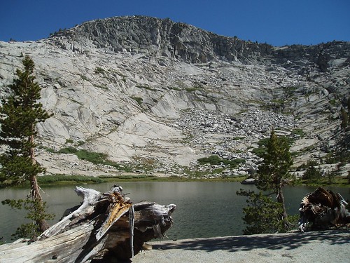
We passed the lower lake and at around 3:45 pm we collapsed at a campsite between the two lakes, with a great view of both (and of Mt. Shinn, looming above). We spent the rest of the day recovering...and meanwhile talking about putting together an alternate route.
Part 2
Part 3
Sunday, July 08, 2007
LeConte Divide Trip Report - Part 1
Subscribe to:
Comment Feed (RSS)
|