
Part 1
Next morning, we agreed on a short hiking day; Lou was concerned about his back, and after the first day I didn't exactly have to have my arm twisted. We would complete what I had planned as the first day's route, taking the ridgeline route to Lake 10200. We took our time, having plenty of it on account of the short day, and didn't get out of camp until 8 am.
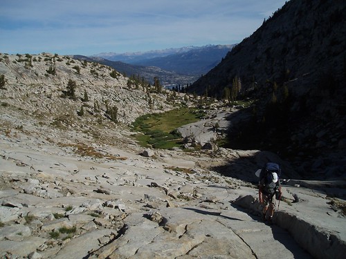
The first objective was Mt. Shinn Pass. We circled the south shore of the lower lake and then turned south up the valley toward the pass. The slabs are the best bet here; the gully itself has some brush and talus. A short riser took us to the meadow below the pass. 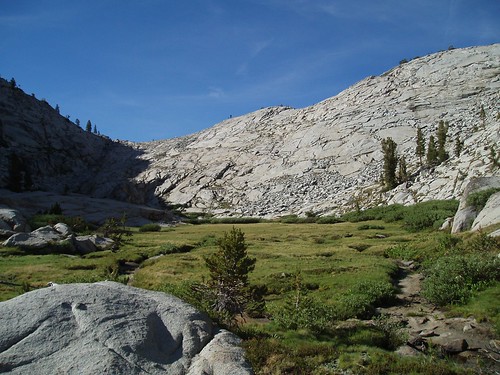
We cut through the meadow and started up the crack on the left side (in shadow here), moving to slabs on the right where that became the easier route. It's an easy climb, and we got to the pass maybe 40 minutes after leaving camp.
From the pass, the ideal is to circle some steep slopes to the left (southeast), dropping very slightly, then angle northeast and up gentler slopes to the ridgeline. Really, it would be very hard to go too wrong on this, but we did get it just right. We reached the ridgeline a little west of Point 10825.
This ridgeline is a wonderful spot. The gentle south slopes make for easy walking; the sheer, deeply glaciated north side gives it an edge-of-the-world feeling; and its position well west of highest peaks gives it a view of the whole sweep of the central Sierra, from Fernandez Peak in the northwest to Sawtooth in the southeast: Ritter and Banner, the Silver Divide, Seven Gables, Humphreys, the Glacier Divide, the Evolution group, Henry, Goddard, the White Divide, the Kaweahs, and Silliman, all within its sightline. We took a break up top to appreciate the view. 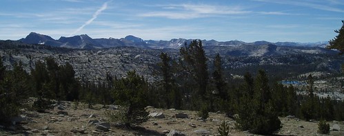
Moving again, we continued along the ridgeline to the junction with the Ward Mountain ridge. The ideal here is to drop along a series of shallow gullies toward the lake. Instead, we wound up descending the narrow, steep-walled gully that cuts NNE all the way from the Divide to a point past the lake. This wasn't wrong, exactly--it got us there, and fairly directly--but it did involve a little more clambering than the ideal route. We cut east from the gully just before the east wall got very cliffy, which turned out to be just right; we went over a low rise and down ramps to the west shore of the lake. We circled the north side and dropped our packs at the base of the ridgelet to the east. 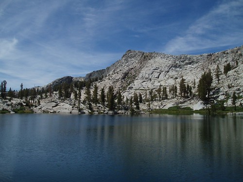
I fell in love with this lake when I came here back in 2004, and I was delighted to find it just as beautiful as I remembered. The lake itself is a classic emerald green or deep blue (depending on angle and time of day) Sierra lake, complete with forest fringe, granite cliffs, and the Ward Mountain fin looming to the north. The ridgelet above the east shore has a spectacular 180 degree view of the area, including the Senger-Hooper complex, Piute Creek Canyon, the Glacier Divide, and (very prominently) Mt. Henry. After debating the relative merits of shade, view, and mosquitolessness, we set up camp on this ridgelet, with a view of the lake as well as the full panorama. 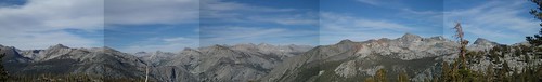
Over the course of a lazy afternoon by the lake, we discussed where to go from here. Bonita and Heather Lake were options, but that would be a speculative route with a lot of potentially tough forest cross-country travel (less than ideal for Lou's back), with another day backtracking over the same territory. Another option was going over to Red Rock Basin, then Lost Lake, then out; but we had both been to Lost Lake before, and we were both keen on camping at Ward Mountain Lake. We could go over to Ward Mountain Lake the next day, take a layover there, and then hike out, but there wasn't much exploration potential in that basin. So eventually we settled on taking a layover day at Lake 10200--worth it for the view, at any rate--with a dayhike into Red Rock Basin. I had led a group there in 1996, and had fond memories of the place.
Next day we had another leisurely morning. After breakfast we packed up lunches and such, and started off a little after 8 am. We headed for an obvious grassy crack leading straight up the ridge, which we had seen from the lake. 
It was steepish and rocky in spots, but it went, taking us up to a notch pass on the Divide. We detoured southeast, traversing to a tarn that had looked intriguing (these tarns always look better from a distance, though), then dropped into Red Rock Basin. 
Red Rock Basin is a gentle expanse of huge meadows, forest, and big slab granite. It's a less dramatic landscape than that north of the Divide, but it has its charms. We descended from the ridge to the largest lake, which we circled on the west side.
Lou headed back to camp from here (his back was starting to bother him), straight up the drainage to the pass, while I meandered east to explore more of the basin. I ended up coming back via a beautiful slab system on the east side of the next spur ridge. I caught up with Lou on the way down from the pass, and we both got back to camp a little before noon. Not a hugely ambitious dayhike, but an enjoyable one, and another lovely day in the mountains.
Part 3
Monday, July 09, 2007
LeConte Divide Trip Report - Part 2
Subscribe to:
Comment Feed (RSS)
|