
Part 1 left off on Day 3, a layover at Lake 10785 with a dayhike to Volcanic Lakes. But before I continue, I need to back up just a bit, to before our dayhike... 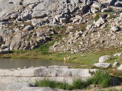
While the three of us were having breakfast that morning, we suddenly noticed a 4-point buck wading toward us through the shallows at the lake's edge. He climbed up out of the water and continued to amble toward us. 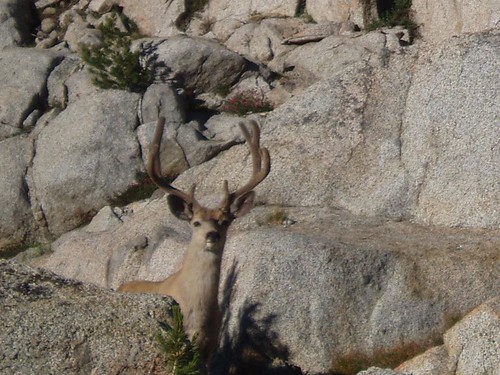
When he was about 20 feet away, I decided that was quite close enough thank you, and boldly retreated a ways. He turned a bit and bypassed our campsite, continuing over the outlet stream, into the rocks, and out of sight. I don't think he'd have come nearly as close if we had been a larger group; this and our other wildlife encounters were a great advantage of being such a small party.
The morning of Day 4, we shouldered our still too-heavy packs and lumbered out into the world again, this time (for the first time in the trip) into territory I hadn't yet traveled. We traversed around the granite knoll north of the lake until we found a grassy chute, which we followed down to the gentler slabs east of the meadow below Granite Pass. From there we crossed the north end of the meadow and found the trail, which we followed two more meadow-steps down. 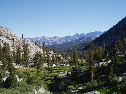
At the north end of the second meadow, we cut off trail again. With the help of my binoculars, we were able to spot Shorty's cabin at the opposite end of the meadow; I had considered a detour to visit the cabin, but mosquitoes made that much less appealing. We stopped at the saddle east of the knoll there (the trail descends west of the knoll) while I scouted our next move.
As it happened, the way north was much more cliffy than I had hoped. I found a ramp, which we followed down until it ended in cliffs; then we traversed east to a ledge that tooks us down (with a little rock-hopping). A little dicier than I had intended, but we made it down safely. The good news was that we were able to bypass a large and nasty pile of talus and brush. We traversed north, climbing somewhat once we were past the talus, and rounded the corner into the western Glacier Lake drainage.
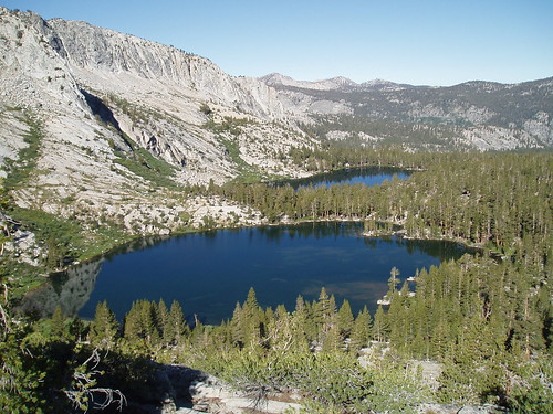
We hit the drainage almost exactly where I had intended, but found the way upstream to the lowest lake blocked by cliffs and waterfall; that forced us to climb a ways upslope through massive shattered boulders and then drop to the lake's outlet. We crossed and then passed the lake on the easy north side. From here, it was all gentle slabs and open forest to the first large lake. The way to the highest lake was only a little steeper, and we got there after another 20 minutes or so. 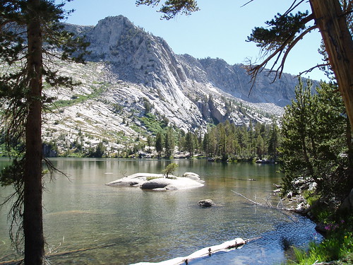
It had turned out to be a more difficult day than planned (tougher going, more complicated routefinding), but we still got there in time for lunch. Yet another advantage of the small group: less inertia, fewer (and shorter) delays, faster traveling.
Another great campsite...a lazy afternoon of reading and exploring...another lovely alpenglow...you know--the usual stuff. 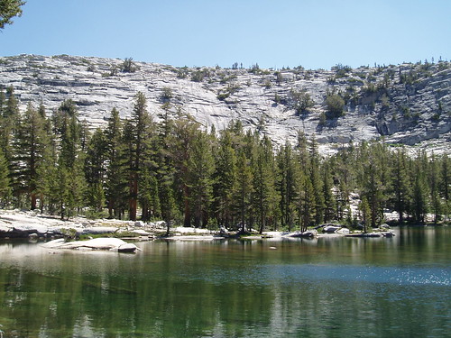
Next morning, Day 5, we saddled up again for what looked like it might be a tough day (two ridge crossings, one fairly minor but the other pretty substantial). We got up top the ridge pictured here pretty easily (via gentle slabs to the left, out of the frame), but then encountered the question of how to get down the north side (all cliffs, at least in our immediate vicinity). I scouted around a bit, and decided our best bet was to follow the ridgeline south toward the upper lake (where it looked like the terrain was less cliffy) rather than trying to drop down to the lower one. (Also: great views from the ridgeline, including the shot at the very top of this post.)
It ended up working perfectly. As we approached the wall of the upper lake, we dropped a couple of benches to where we could follow a meadowy bench to exactly where we needed to be: the lower end of a grassy chute that would take us over the wall to the upper lake. We climbed the chute, skirted the tarn on the other side, traversed down to the lakeshore and followed it to the outlet--where we took a well-deserved break. 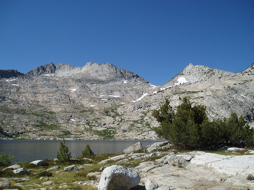
The highest Glacier Lake is a real beauty, set in a big wide-open basin below picturesquely jagged peaks, with grand views north toward the Black Divide and the Sierra crest. It was not, however, our destination. After getting a little rest and a lot of pictures, we saddled up again and began the slog up the ridge east of the lake. The route was pretty obvious--the forested gully south of the knoll east of the outlet--but the going was steep, too steep to get a good breathing rhythm. After the first 400 feet, though, we got to a much gentler small grassy valley meandering toward the ridgeline. (This is one of the things I love about the Sierra: the multitude of micro-landscapes, pocket meadows and benches and tiny valleys.) This took us to another short steep climb to the ridgeline.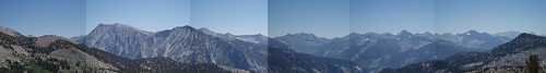
And...wow. The first two days we had panoramic views to the south; days 2 through 4 we had amazing views to the north. Crossing the ridge between Glacier Lakes and the Kid Creek drainage, we got an awesome panorama of the rugged and labyrinthine alpine country to the east: of Arrow Peak, looming over the Muro Blanco; of perfectly formed Mt. Clarence King, double-peaked Mt. Cotter, and stately Mt. Gardiner with its massive walls and buttresses; of Mt. Gould, Dragon Peak, and a few others poking up from the crest; of the whole Kings-Kern Divide; of the Brewer massif, nestled behind a saddle on the Kid Peak ridge. (Click through to the largest size for the full effect.) It was a wild and exhilarating view, the more so for the effort it took us to get there. It was also the gateway to a remote basin I had never visited but had long looked at as a worthy objective.
We ate lunch on the pass, staying there a little over an hour. Finally we put on our packs again and did the short drop down steep grassy slopes to a campsite directly below, in a grove of trees I had spotted from the pass. We got into camp around 1:30, after another tough but short but satisfying day of travel. 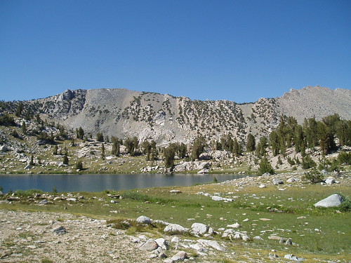
Our site was a little downhill from this lake, which is almost perfectly round. 
This was the view--rather, a view--from our campsite. 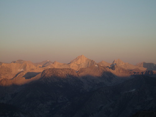
More lazing around...more exploring...more alpenglow in the evening. Another fantastic day in the mountains.
Part 3
Part 4
[That's all, folks]
Thursday, August 24, 2006
Monarch Divide Trip Report: Part 2
Subscribe to:
Comment Feed (RSS)
|