
Part 1 covered the first three days; Part 2 covered days 4 & 5 (plus a little bit of day 3).
Day 6 was another layover, this time in the North Fork Kid Creek basin. We were at the most remote point of our trip, furthest from the trailhead and most isolated from the haunts of other hikers, and we had a free day to savor our solitude...
We had discussed the possibility of climbing Dougherty Peak, but decided instead to hike a couple of miles to a point overlooking the Muro Blanco. The Muro Blanco is a huge glacially-carved valley with no trails and very few visitors. The route down the Muro Blanco is one of the 'classic' Sierra bushwhacks, a difficult 2-day (minimum) thrash through mile after mile of brush and talus and, just for a change, occasional stands of alder. My appetite for that sort of travel isn't what it used to be (and I was never particularly ravenous), and barring some kind of temporary insanity it's unlikely that I'll ever do that trip...but judging from the map, I thought we had within our grasp an opportunity to look into the heart of the Muro Blanco without suffering the near-death-of-a-thousand-cuts that awaits the ground-level Muroblanquistador1.
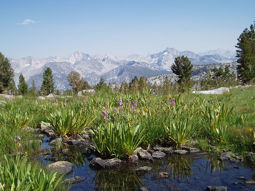
The basic route was to contour around the north side of the basin, gaining or losing elevation as necessary to avoid cliffs. We headed more or less ENE over the low rise and dropped to the outlet of the small lake, then contoured east through open forest, dropping a little at the far end to avoid talus and brush. 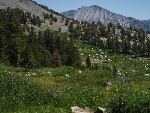
We passed through a great lush garden that covered a goodly portion of the mountainside, before gaining slightly to cross a low ridge. Here we climbed a little more to a well-defined bench (or series of benches, really) that took us above a set of cliffs. At the end of the benches, we had to contour across some steeper, looser ground--smallish rocks in loose soil--before winding up in forest again.
This took us to the ridgeline--made obvious by the yawning emptiness on the other side--which we followed south along a level promontory until it ended in an open rocky point. 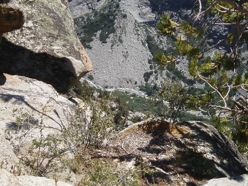
And by 'ended', I mean the next step would have been 2800' straight down. 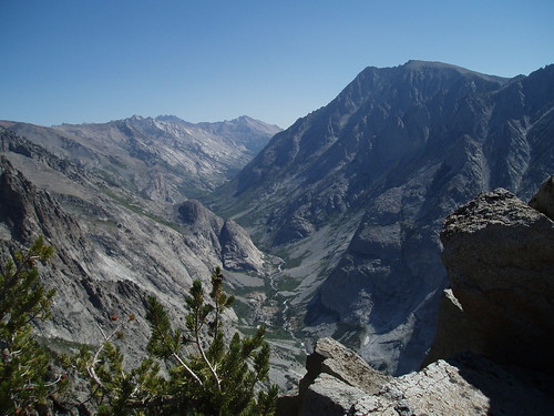
Perched on the edge of the abyss, this really is (as Gene called it) 'the Glacier Point of the Muro Blanco'. Photos (well...my photos, anyway) can't possibly convey the sense of grandeur, of vastness, that you get being there. This is looking northeast up the valley toward the Sierra crest (Cardinal Mountain in the distance). If you look at the full-size image, you can get an idea of the brush and talus that choke the valley. 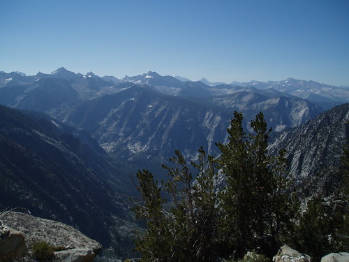
This is looking southeast toward the junction with Woods Creek and the beginning of Paradise Valley, and the sea of peaks beyond.
We lingered at the point about an hour and a half and then headed back to camp the way we had come.
Now, so far I've said next to nothing about the weather. That's because there wasn't any. Not a cloud for the first 4 days, maybe two tiny wisps in the distance on day 5. At no point on the trip was there even the remotest threat of rain.
That afternoon in the North Fork Kid Creek basin, though, we had a very odd bit of micro-weather. For most of the afternoon, small clouds were forming directly over the ridge we had crossed on day 5--and, not incidentally, directly in front of the sun, casting a shadow on our camp. Each cloud would form from nothing, then drift lazily away to the east, at which point another would form in its place. The thing about altitude is that although it feels hot in the sun, the air temperature may actually be pretty cool (in the 60s, say), so you get in the shade and it feels chilly. Add a breeze and you start putting on your cold weather gear. For much of the afternoon, it was sunny all over Kings Canyon National Park (there were no other clouds besides our friendly local ones) and downright cold where we were.
That's the only complaint I have about the weather for the entire trip--apart from it being pretty warm at the start and the very finish, but that's normal--which isn't bad.
Next morning we packed up again and headed for Kid Lakes. The route was to be through the valley and then up across the ridge to our south; we needed to cross the ridge high enough to avoid a tangle of spur ridges on the other side. If we crossed at the right point, we'd be able to drop directly down to the two lowest lakes in the basin.
It all worked beautifully, up to a point. We dropped straight into the valley until we were stopped by cliffs, then traversed east to a grassy gully that took us the rest of the way down. On the other side, we followed an obvious ramp system I had seen from camp. We hit the ridge exactly where we needed to, and dropped down the other side, bearing slightly west so as to hit the right drainage. We came to a lovely meadow, visible on the topo as a round flat space north of the lake valley. 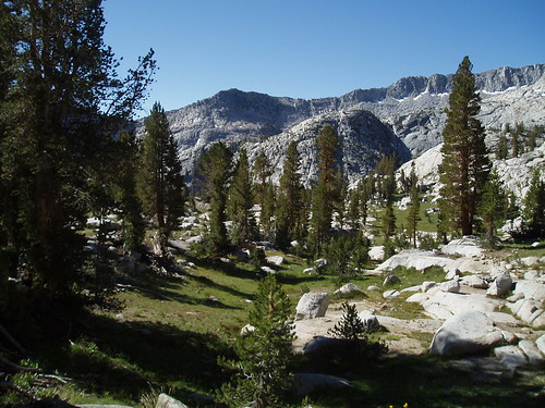
Now we flash back 16 years, to the summer of 1990. My wife and I had just separated, and I was crashing on friends' floors and couches. I went for the best therapy I could think of: a week in the mountains. The second half would be car camping in Mineral King; the first half, a trip on the Monarch Divide, which I remembered fondly from an ill-starred trip ten years before. Looking at the topo, I picked out Kid Lakes basin as my destination; it looked remote and spectacular, it wasn't in any of the guide books, and I hadn't heard of anyone going there.
It exceeded all my expectations. I was overwhelmed by the spectacular views and the small, intimate beauty, the high peaks and vast canyons and the green turfy pocket meadows with crystal clear streams running through them. I camped above Lake 10620 and dayhiked to the lowest Kid Lake, and up to this meadow.
And of course I shot a couple of rolls of great pictures. When I got them developed, they looked great. I showed a few friends at work, and they agreed. And they were in my small bag of belongings when it was stolen from a friend's car.
I returned in 1997, but due to circumstances I don't recall I didn't have a camera. So again, no Kid Lakes pictures.
So for me, coming back to Kid Lakes meant reclaiming a part of my past that had been lost. Beginning with this valley with its classic timberline meadow.
We dropped down toward the lake valley. I tried to bear west in order to visit the second-lowest lake, but the grain of the granite kept pushing us east, so I abandoned that plan and settled for visiting just the lowest lake. 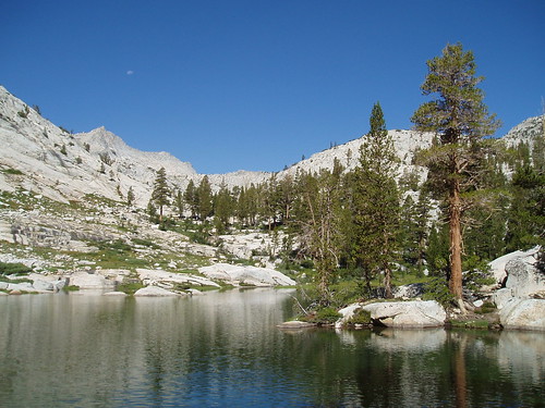
Which, to my happy surprise, was just as beautiful as I remembered it. It's shaped like a sort of irregular crescent; the eastern end has cliffs towering over its south side, while the western end provides views up the valley to the peaks of Goat Crest. We took a good long break here.
I was happily surprised by something else as well. In 1990, I found no real sign of human visitation in the Kid Lakes. In 1997, though, we found a recently-cut packer trail through the area, all the way over Mungoat Pass. In some places, the brush had been cut away to make passage for mules; the campsite near the lowest lake was filthy with mule droppings. It was heartbreaking to see this once-pristine area so abused, and when I got home I wrote a letter to the Park Service. I actually got a reply, and spoke to a guy on the phone who seemed genuinely interested and concerned about the abuse of off-trail areas by packers.
So this time, I was looking to see what remained of the damage. Happily, there was almost nothing--just a trace here and there of use trail. Again, I felt like my original memories had been restored to me.
After hanging out at the lowest lake a while, we continued down the valley and then turned the corner up towards Lake 10620. The way up was easy, first on ramps and slabs well north of the outlet stream, then closer to the stream as we approached the lake. 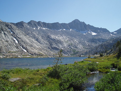
Which also lived up to my memory of it. This is a narrow, fjord-like lake in a big glacially-carved valley. To the southwest are the dramatic cliffs and pinnacles of Goat Mountain; to the northeast is the Muro Blanco, and all of the peaks surrounding it--Dougherty, State, Marion, Ruskin, Arrow--all the way to 14,000' Split Mountain on the Sierra crest. We camped on a bench near the outlet stream, with a prime view in both directions--maybe the most spectacular campsite of the whole trip. 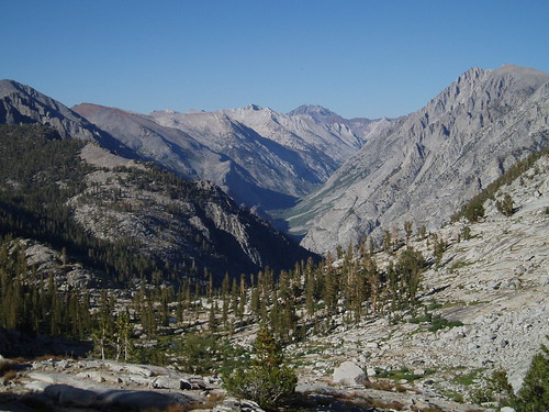
Once again, we got into camp by lunchtime and had the whole afternoon and evening to soak in the spectacle. Another great day in the mountains.
1If you're curious, there are trip reports by Muroblanquistadores here and here, and photos (no report) here.
Part 4
[That's all, folks]
Saturday, August 26, 2006
Monarch Divide Trip Report: Part 3
Subscribe to:
Comment Feed (RSS)
|