
[Here are Part 1, Part 2, and Part 3.]
I awoke on Day 8 to find frost on my groundcloth--the coldest morning yet. The northeast/southwest orientation of the Lake 10620 valley seems to keep it a good deal cooler than the surrounding basins. I got the stove going and soon we all had coffee and oatmeal to warm us up.
Our route that day was over Mungoat Pass to Grouse Lake, with a side dayhike from the pass to Goat Mountain. My recollection from years before was that once we got high enough, there was a long straight route along a fissure in the granite which would take us directly to the base of the pass. I was a little nervous because we could see a snowfield near the top of the pass, which could make it a much more difficult crossing.
We crossed the outlet stream and followed the lakeshore on the southeast side. Detouring around the little inlet near the northeast end, we passed through an area still shadowed by the valley walls, where frost covered the meadow and puddles were all iced over. 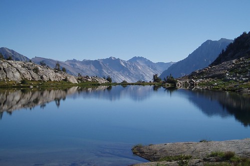
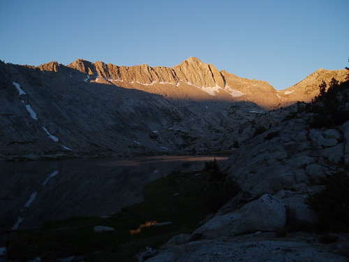
Looking back, we had grand views of Arrow Peak above the glassy lake.
At the far end of the lake we began to climb to the northwest along a series of ramps and benches, aiming to intercept the straight route to the pass. It was fairly easy going--each bench seemed to have a stairway or a ramp to the next bench--and when we had gained about 400' we arrived at the Kid Lakes Freeway. It's a series of meadowy benches, each a little higher than the one before, all strung along the same granite fissure, with a lovely alpine stream running down the middle. As you get higher, you come to a long stretch of granite wall, maybe 15-20 feet high, hemming in the streambed on your left.
It was in this section, as we were approaching the end of one bench and the beginning of the rocky rise to the next, that Renee saw another bear--this one cinnamon-colored. Alas, it ran away before I could get my camera out. 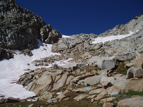
Eventually, we came to the base of the pass. The northeast side of Mungoat Pass is steep and rocky, with cliffs in the center and big-block talus on the left (as you look up from below); the standard route is to climb up loose dirt and scree to the right of the cliffs. The close-up view confirmed my fears: the large snowfield covered this right-hand passage.
As we got into the rocky section, the route got a lot trickier, and at one point we ended up having to backtrack (handing packs down a short cliff) after getting one level higher than we wanted to be. It was a minor detour, but annoying and enervating. Eventually we wound up at the base of the snowfield.
Gene, who is much more comfortable on snow than I am, went directly up the snowfield; Renee and I skirted the downhill side to the right, to where we could cross it at a narrow point. Not my favorite stuff: the snow was steep, and it wasn't as soft as I'd have liked (it was just soft enough for kick-steps, though). Once across, we had to clamber over some big-block talus with fully loaded packs--and that's not as easy as it sounds. We made it through, though, and up the last 30' or so of loose dirt and gravel to the top of the pass. 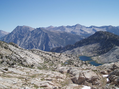
Looking down from the top, I remembered my dismay upon reaching the top 16 years ago; it really does look steep. (Obviously, I did find a way down.) I was also reminded of the great views back toward Lake 10620 and Arrow Ridge. Unfortunately, we also had a fierce wind that made us disinclined to stay long.
The way up Goat Mountain is steeper and more intimidating than Secor makes it sound, and we were all a little tired from the tougher-than-expected climb to the pass, so we abandoned any thought of bagging it on this trip.
Dropping down to Grouse Lake, the grain of the granite kept pushing us to the right, where I knew we would eventually encounter cliffs; so we forced a way to the left, crossing one granite rib after another, until eventually we emerged in a gentle slabby area. This took us down to a grassy streambed, which we followed most of the way down to the lakeshore.
It was along this stretch that I made a single misstep descending a slab and wound up on my butt. Nothing injured, except for a blood blister on my thumb, but this sort of thing always leaves me a little shaken. Shaken enough, in this case, to forget about my map (which I had been carrying in my hand). When I realized later that I had left it, I was very bummed--not just because I love my maps, but also because I hated to litter (even accidentally). 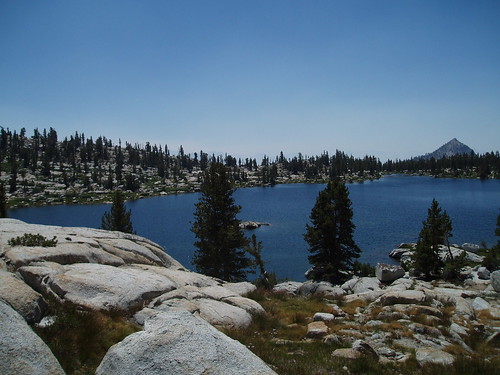
We got down to the lake without further incident and followed the eastern shoreline, more or less, toward the south end of the lake. Near the southeast end we had to detour around a series of small tarns, then cross the outlet stream to a large level area with lots of camping potential. (Unfortunately, it has also seen a lot of camping, and the best lakeview sites are looking a lot more tired than they did 9 years ago.) We set up camp a fair distance from the lake and settled in for another lazy afternoon. 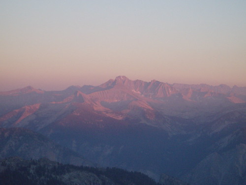
After dinner, we headed over to the ridgelet east of the outlet stream. This spot has outstanding views of King Spur, the Kings-Kern Divide, the Brewer massif and Sphinx Crest, Silliman Crest, and all the way south to the Kaweah Peaks; in other words, it's Alpenglow Central. A lovely final evening for a spectacular trip.
Next morning we got on our way around 8 am. We weren't exactly on a schedule, but we knew the Cedar Grove showers were closed from 1 to 3 pm, so we had a strong motivation to get to the trailhead by noon or shortly thereafter. We had about a mile of cross-country travel back to the trail; I had done this a couple of times, but (as it turned out) didn't have the clearest memory of it. I knew we needed first to pass the lovely meadow southwest of Grouse Lake, and we got there with no problem.
That's when it got complicated.
I started out contouring from the meadow, along what looked like a faint use trail, and wound up in a bunch of big-block talus with manzanita. After thrashing around a bit, I figured our best way out was up, so we made our way upslope through the talus maze. After maybe 15 minutes we emerged in open forest, and a few minutes later I spotted the real use trail. I think the best bet from the meadow would have been to climb to the ridgetop, and thus avoid the talus. Next time I go this way I'll remember that.
But we reached the trail without further problem, and began the long descent to the valley. The switchbacks down to Upper Tent Meadow seemed endless, much longer than I was expecting--and yes, I know that they were also longer than I had expected going up a week before, and that they had been longer than I expected just two weeks before that, so at this point you might be wondering about my memory. I don't know; I can't explain it. Somehow I just have a mental block where this section is concerned. 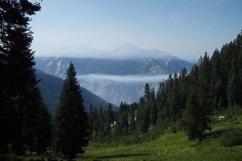
At various points on the trip, we had seen smoke from a fire that appeared to be somewhere south of Kings Canyon. It made our views a little hazy at times, but wasn't much of a factor otherwise. Now, though, as we emerged from the forest, we could see a thick blanket of smoke choking the valley.
We stopped for water and a brief rest at Lower Tent Meadow, then continued down the trail at a brisk pace. The lush meadow and forests near Copper Creek gave way to a drier, warmer zone as the trail made the long traverse south.
Back in 1990, I did the whole distance from Kid Lakes basin (camped a few hundred feet above Lake 10620) to Roads End in a single morning. When I got to this part of the trail, I saw a ranger a hundred yards or so ahead who yelled at me to stop. 10+ miles and a 6600' drop, and maybe two miles shy of the end I had to stand there and wait while he was trying to round up some horses that had bolted off the trail.
Then the two horses that were still on trail began coming toward me, and the ranger yelled at me to stop them. I asked "what do I do, just stand in their way?", but got no response. So I tried that. The first horse started to nudge past me. So then I ever-so-gingerly took hold of some piece of apparatus in the general vicinity of the horse's head, and hoped for the best. The horse stopped; the second horse kept going; they wound up turned around; but they stopped, and I stood there holding this horse and feeling like a complete idiot. Eventually the ranger got to where I was and told me I could continue but to detour uphill of the trail to avoid the horses that were still out of control.
Good times.
No such incident interrupted us this time, and we soon made it to the open switchbacks that marked the last stretch. 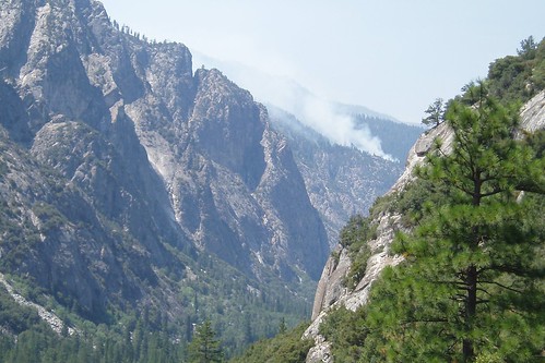
From here, we could see the source of (at least some of) the smoke--a fire up in the Roaring River drainage. A map at Cedar Grove identified it as a lightning-caused burn called the Roaring Fire, on Sentinel Ridge. As of Saturday it was still burning (they don't do the old Smoky the Bear 100% fire-suppression thing anymore).
We got to the trailhead around 11:45. We headed over to Cedar Grove and got our showers (about which: ick). We had one last drink together, then went our separate ways.
All in all, it was an awesome trip--fairly challenging at times, but rewarding as well, with spectacular scenery, remote and pristine landscapes, and good company along the way.
[That's all, folks]
Tuesday, August 29, 2006
Monarch Divide Trip Report: Part 4
Subscribe to:
Comment Feed (RSS)
|